by Leland Searles
What began as an effort to create maps of a few watersheds in Iowa has become a full-blown mapping that links the entire Mississippi-Missouri basin from north to south and east to west. A vital part of this is the online digital map of Iowa, developed over months of effort by Nitin Gadia.
Nitin’s map allows you, the user, to look at the big picture in Iowa, then zoom in close to see a specific river section, watershed, or community. There are several map features or “layers,” as they are called in Global Information Systems (GIS). You can use the legend to turn off layers to see only what you want. The idea is to let you see the possibilities for biodiversity core areas and the corridors that would connect them.
The land for cores and corridors usually does not interfere with agricultural uses, because we have selected the steeper slopes and the most frequently flooded land for inclusion. Connectivity with cores and corridors across Iowa can be integrated with the need for farm livelihoods to continue. In addition, while some highways and urban areas present roadblocks, there are ways to imagine corridors that avoid cities and methods to allow wildlife to move over or under major highways that are both wildlife-friendly and safer for human travelers.
You can look at Nitin’s work here. Click on the red “View Map” button.
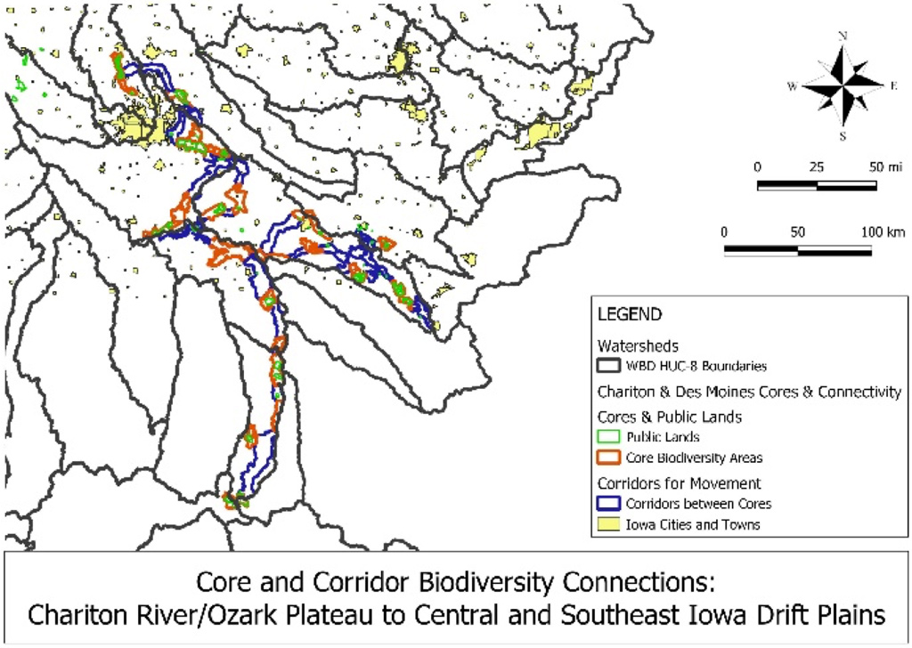
Other mapping work by Leland Searles used different approaches and focused differently on the same watersheds and land types. One result appears in Figure 1, showing how the Chariton, lower Skunk, Des Moines, and South Skunk rivers could be joined with corridors.
Cores and corridors
Cores and corridors may be thought of in these ways: first, as the soil and subsoil through which bacteria, fungi, macroinvertebrates (earthworms, soil insects and other arthropods that are visible to the eye), and roots travel. Many plant species “travel” with their rhizomes or roots to expand their colonies or establish new colonies. Their movements by roots are tiny steps, compared to the movement of their seeds, but small movements can make large differences in the survival of a species or plant community.
Second, the surface is more familiar to us as the major place for our movements, but it is used by many amphibians, birds, insects, mammals, reptiles, spiders, and more. We share the surface with thousands of other creatures, including low-growing plants, mosses, land snails, and more.
Above ground, plants occupy different layers above the soil, and all have preferences for different ecosystems and habitats. A biodiverse prairie may have three layers: shortgrass prairie species, mid-height forbs and grasses, and the tallgrass plants. Each layer has different sorts of wildlife that use it. Likewise, wetlands have different strata, or layers, and those may include plants and animals that live entirely in the water. Perhaps the most obvious are the layers in a mature woodland: canopy trees, understory trees and shrubs, saplings and vines, and herbaceous plants. Again, animal diversity follows this layering with a variety of adaptations for food, nesting, and other needs.
It’s easy to ignore the air that fills the spaces between plants. Airspace is vital, not only for flying creatures, but also for the amount of shade or sun, the dispersal of pollen and seeds and spores, chemical signaling that is used by many animals and plants, and for the self-regulating spacing between plants of the same type. The space and the life forms make up a third major layer.
Over the trees is another airspace that is the fourth layer, occupied mostly by medium to large birds and migrating flocks of all sizes, some seeds, a rich wealth of fungal and moss spores that moved from the surface and vegetated layers, rainfall, snow, clouds, and more. There are stories of tornadoes sucking up entire ponds full of frogs, then depositing the startled frogs a few miles away. Tornadic activity would be a minor means of shifting species around, but not the winds overhead.
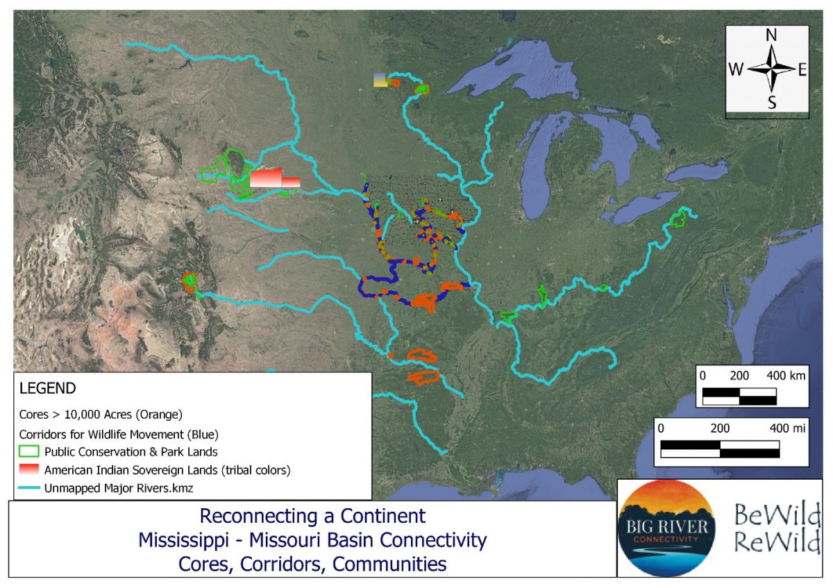
Of course, there are many cycles and movements that are vertical – down and up – as well as horizontal, including the water or hydrologic cycle, the carbon and nitrogen cycles, the absorption and radiation of the sun’s energy, and others. Figure 3 shows the final result of Leland’s mapping work, taking us from a few Iowa watersheds to the much larger Mississippi-Missouri basin. Again, be sure to check out Nitin’s interactive map and click on the red “View Map” button.
The Big Vision
It’s important to remember that these maps are intentional flights of the imagination. How actual cores and corridors emerge on the ground are based on many factors. But these flights of imagination are the starting points, the opening of conversations and actions, that lead to the realization of healthier, more naturally functional landscapes. These landscapes must have the resilience to face the onslaught of human-caused changes: changes in surrounding land uses, protections from technological changes that include widespread use of harmful chemicals, sprawling urban areas with increased stormwater dumping, and climate change.
While we can work toward actual cores and corridors, the final steps are the natural processes that occur without human intervention. Even our attempts to reestablish prairies and other ecosystems are short-term responses that will be subject to these processes. And we’re talking about time scales longer than a few decades or a century. Midwestern prairies may have appeared relatively quickly a few thousand years ago, but they are dependent on natural causes and probably a human presence. What happens when people are removed from the picture almost entirely? What happens when we step back, intentionally or otherwise, and yield control?
Rewilding Iowa’s Landscape and Beyond: A Vision for Coexistence with Nature
BeWildReWild is a vision for allowing the natural world to restore itself with minimal human intervention, alongside human land uses that enhance natural processes. It begins with the question, “What does ‘wild’ mean?” then proceeds from individuals’ answers to the Mississippi River Basin as the space for envisioning and expressing “wildness.” We trust natural systems to adapt to change and rejuvenate land that is severely disturbed and that exceeds human capacity for intensive restoration. Rewilding moves beyond active restoration practices to natural recovery and adaptive processes.
A major element is Big River Connectivity, which addresses issues of scale from the entire basin to localities and species, moving from Space to Species. Iowa is “Ground Zero” for imagining “nature” and “wildness” outside of utilitarian values, forefronting the state as more than an ecological flyover zone between more visible eastern and western landscapes of conservation and protection. The vision entails the creation and expansion of biodiversity cores and corridors across landform regions, using artistic expression, geospatial mapping, and public media to assert the value of connectivity and wildness. Potential cores of more than 10,000 acres throughout Iowa and adjacent states can be connected by corridors that enhance biodiversity and ecological functions. Trophic rewilding, e.g., with apex predators, is crucial, given strong evidence for ecological recovery after their reappearance. We anticipate a cultural shift from an extractive, utilitarian economy to one based on human-nonhuman reciprocities in which our species stewards and values biodiversity now and in the future.
Check out Big River Connectivity presentations for information.
In connection with that, we have begun locating volunteers across Iowa to evaluate wildlife crossings as part of the siting of corridors. The Wildlife Crossing Scorecard page provides brief descriptions of what and why.
For more information, visit the other projects, the Forum, and other parts of the BeWildReWild website.