Produced by Leland Searles
The Iowa River Connectivity mapping project has been a learning experience that covered the vision and basic elements of the BeWildRewild and Big River Connectivity efforts. There was the struggle to learn at least the basics of a geospatial mapping software, QGIS, to design and produce maps. Using aerial photography and other kinds of maps, I had to determine what I would outline as cores and corridors that were large enough to allow rewilding of every possible form of biodiversity: ecosystems, plant communities, scarce plant species, intact remnant soils, the plethora of insects and spiders, carnivores of all kinds but especially larger ones, and more.
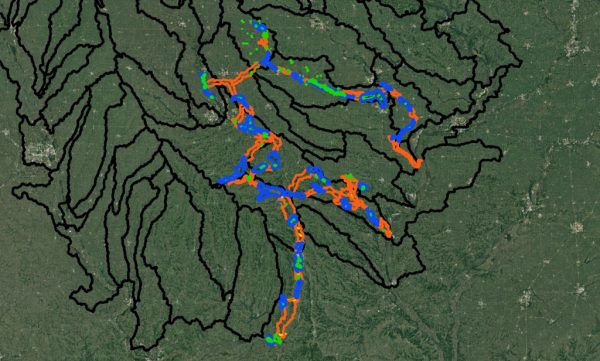
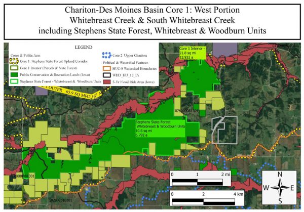
I’ve settled on placing cores around large tracts of public land because these already exist as “hotspots,” and they already protect biodiversity to some degree. For example, Iowa’s state forests include considerable expanses of land, although these are broken into detached units. Including these units in a single core or connecting them with corridors is vital. Their fragmentation and size highlight the importance of establishing corridors for movement between each tract.
In the bigger picture, movement across the vast expanses of the Mississippi-Missouri basin is at stake. Cores and corridors can focus on the biodiversity in and connections between specific land units and small watersheds, but it also needs to take a satellite’s view of landform regions, major river basins, and the entire M-M basin, from the Rockies to the Appalachians, and from the Canadian Plains to the Gulf of Mexico.
The locations of wildlife corridors need to take into account long-distance movements of animals and plants across Iowa’s Des Moines lobe glacial surface (central and northern Iowa, the Southern Drift Plains, and the Ozark Plateau in Missouri. The corridors often will follow river valleys, but they also need to cross watershed divides. In some cases, large rivers are natural obstacles to movement. While natural obstacles existed centuries ago and helped define regional and ecosystem differences, animals and plants still managed to cross or skirt them, keeping populations connected. How does one capture all this in a map? A familiarity with watersheds and the divides between them, the present-day land uses and ecological hotspots, the ranges of animals and plants, and the history of change in the landscapes and species is helpful in fostering a vision of what is still possible. The Iowa River is a small part of the overall remapping not only of on-the-ground possibilities but also of our imaginations. The bigger change is on the part of we humans, so that our biases, misinformation, land use practices, economic and social pressures, and more all come under examination.
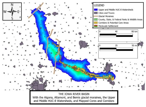
The Iowa River crosses four major landforms. At the upstream end, its headwaters have cut into a major glacial feature in northwest Hancock County, the Algona moraine. A glacial moraine marks the end of an advancing glacier; from that point it melts and retreats. Downstream, the Iowa crosses two other, older moraines, the Altamont and the Bemis, that also mark earlier glacial advances, with the Bemis being the oldest. The Bemis moraine is the boundary of the entire Des Moines lobe. Iowa is famous for the crop productivity of the soils in this region, because they are the least sloping (on average), and once they held the richest organic matter that made them so fertile.
The Iowa leaves the Des Moines lobe a little south of Eldora, in Hardin County, where it enters the Iowan Surface landform. The Iowan Surface also was formed by glaciers, but much earlier than the Wisconsin glacial period that produced the Des Moines lobe and the Bemis moraine. Erosion over several hundred thousand years has cut down the Iowa Surface so that gently rolling hills and extensive drainage networks dominate the surface. The lower Iowa watercourse flows through the Southern Iowa Drift Plains, also glacial in origin, but even more highly cut by well-developed drainage networks and more pronounced hill-valley terrain.
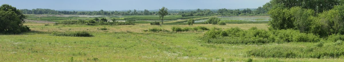
Eventually, the river enters the Mississippi floodplain, the fourth landform, shortly before spilling into the Mississippi itself. As the land near the Mississippi levels out, large marshes still hold and store water and provide abundant wetland habitats for birds, aquatic frogs, insects, mammals, plants, and turtles.
Despite significant city and town development and despite the transformation of much of the Iowa’s basin in agricultural uses, it still holds treasuries of animal and plant diversity at locations like Fallen Rock, Marietta Sand Prairie, Timmons Grove, Otter Creek Wetlands, Hawkeye Wildlife Management Area, Cone Marsh, and more. Well over 200 species of native plants live in the roadsides of some counties. The preservation of all these relies, in part, on reestablishing connections among them, overcoming the fragmented ecology and barriers to the natural processes that maintain biodiversity. Ultimately, these natural processes also are the foundation of human existence in the Iowa corridor, but it is worthwhile to step away from the needs and wants of our species to consider the needs of nonhuman life forms and the big-picture landscapes around us.
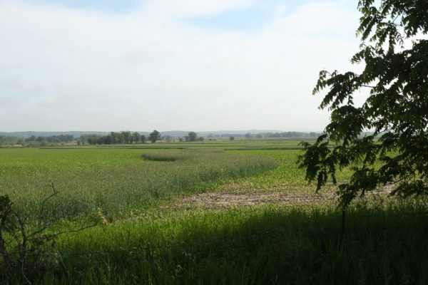
Figure 5, right: Oxbow wetland at Timmons Grove, Marshall County, the old channel of the Iowa River.